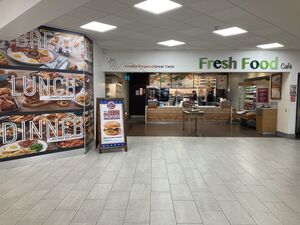
This is a map of official service areas with a Fresh Food Café restaurant. Tapping each icon will reveal more details, with a link to a detailed database page.
If the map doesn't load properly, try refreshing this page. There are more search options below.
Loading map... If nothing is happening, try refreshing the page.
{"minzoom":5,"maxzoom":15,"mappingservice":"leaflet","width":"auto","height":"575px","centre":{"text":"","title":"","link":"","lat":53.917281000000002677552402019500732421875,"lon":-2.285156000000000187100113180349580943584442138671875,"icon":""},"title":"","label":"","icon":"","lines":[],"polygons":[],"circles":[],"rectangles":[],"copycoords":false,"static":false,"zoom":6,"defzoom":14,"layers":["OpenStreetMap.DE"],"image layers":[],"overlays":[],"resizable":true,"fullscreen":false,"scrollwheelzoom":true,"cluster":false,"clustermaxzoom":20,"clusterzoomonclick":true,"clustermaxradius":80,"clusterspiderfy":true,"geojson":"","clicktarget":"","imageLayers":[],"locations":[{"text":"\u003Cdiv class=\"mw-parser-output\"\u003E\u003Cp\u003E\u003Ca href=\"/Strensham\" title=\"Strensham\"\u003EStrensham services\u003C/a\u003E\u003Cbr /\u003EOperated by Roadchef\u003Cbr /\u003E\u003Cbr /\u003EM5 between J7 and J8\n\u003C/p\u003E\u003C/div\u003E","title":"Strensham servicesOperated by RoadchefM5 between J7 and J8\n","link":"","lat":52.06227200000000010504663805477321147918701171875,"lon":-2.15006479999999999819237928022630512714385986328125,"icon":"/wiki/images/5/5d/Icon-MSA.png"},{"text":"\u003Cdiv class=\"mw-parser-output\"\u003E\u003Cp\u003E\u003Ca href=\"/Tibshelf\" title=\"Tibshelf\"\u003ETibshelf services\u003C/a\u003E\u003Cbr /\u003EOperated by Roadchef\u003Cbr /\u003E\u003Cbr /\u003EM1 between J28 and J29\n\u003C/p\u003E\u003C/div\u003E","title":"Tibshelf servicesOperated by RoadchefM1 between J28 and J29\n","link":"","lat":53.1380630000000024892869987525045871734619140625,"lon":-1.3308424000000000919641252039582468569278717041015625,"icon":"/wiki/images/5/5d/Icon-MSA.png"},{"text":"\u003Cdiv class=\"mw-parser-output\"\u003E\u003Cp\u003E\u003Ca href=\"/Northampton\" title=\"Northampton\"\u003ENorthampton services\u003C/a\u003E\u003Cbr /\u003EOperated by Roadchef\u003Cbr /\u003E\u003Cbr /\u003EM1 at J15A and A43\n\u003C/p\u003E\u003C/div\u003E","title":"Northampton servicesOperated by RoadchefM1 at J15A and A43\n","link":"","lat":52.2094129999999978508640197105705738067626953125,"lon":-0.9435213399999999861478272578096948564052581787109375,"icon":"/wiki/images/5/5d/Icon-MSA.png"},{"text":"\u003Cdiv class=\"mw-parser-output\"\u003E\u003Cp\u003E\u003Ca href=\"/Norton_Canes\" title=\"Norton Canes\"\u003ENorton Canes services\u003C/a\u003E\u003Cbr /\u003EOperated by Roadchef\u003Cbr /\u003E\u003Cbr /\u003EM6 Toll between JT6 and JT7\n\u003C/p\u003E\u003C/div\u003E","title":"Norton Canes servicesOperated by RoadchefM6 Toll between JT6 and JT7\n","link":"","lat":52.66483699999999856800059205852448940277099609375,"lon":-1.9675290000000000834035063235205598175525665283203125,"icon":"/wiki/images/5/5d/Icon-MSA.png"},{"text":"\u003Cdiv class=\"mw-parser-output\"\u003E\u003Cp\u003E\u003Ca href=\"/Rownhams\" title=\"Rownhams\"\u003ERownhams services\u003C/a\u003E\u003Cbr /\u003EOperated by Roadchef\u003Cbr /\u003E\u003Cbr /\u003EM27 between J3 and J4\n\u003C/p\u003E\u003C/div\u003E","title":"Rownhams servicesOperated by RoadchefM27 between J3 and J4\n","link":"","lat":50.95753500000000002501110429875552654266357421875,"lon":-1.448313699999999926149030216038227081298828125,"icon":"/wiki/images/5/5d/Icon-MSA.png"},{"text":"\u003Cdiv class=\"mw-parser-output\"\u003E\u003Cp\u003E\u003Ca href=\"/Sandbach\" title=\"Sandbach\"\u003ESandbach services\u003C/a\u003E\u003Cbr /\u003EOperated by Roadchef\u003Cbr /\u003E\u003Cbr /\u003EM6 between J16 and J17\n\u003C/p\u003E\u003C/div\u003E","title":"Sandbach servicesOperated by RoadchefM6 between J16 and J17\n","link":"","lat":53.13937399999999655619831173680722713470458984375,"lon":-2.33656549999999985089971232810057699680328369140625,"icon":"/wiki/images/5/5d/Icon-MSA.png"},{"text":"\u003Cdiv class=\"mw-parser-output\"\u003E\u003Cp\u003E\u003Ca href=\"/Sedgemoor_(South)\" title=\"Sedgemoor (South)\"\u003ESedgemoor services\u003C/a\u003E\u003Cbr /\u003EOperated by Roadchef\u003Cbr /\u003E\u003Cbr /\u003EM5 southbound between J21 and J22\n\u003C/p\u003E\u003C/div\u003E","title":"Sedgemoor servicesOperated by RoadchefM5 southbound between J21 and J22\n","link":"","lat":51.26919500000000340378392138518393039703369140625,"lon":-2.91954199999999985948306857608258724212646484375,"icon":"/wiki/images/5/5d/Icon-MSA.png"},{"text":"\u003Cdiv class=\"mw-parser-output\"\u003E\u003Cp\u003E\u003Ca href=\"/Taunton_Deane\" title=\"Taunton Deane\"\u003ETaunton Deane services\u003C/a\u003E\u003Cbr /\u003EOperated by Roadchef\u003Cbr /\u003E\u003Cbr /\u003EM5 between J25 and J26\n\u003C/p\u003E\u003C/div\u003E","title":"Taunton Deane servicesOperated by RoadchefM5 between J25 and J26\n","link":"","lat":50.97690899999999913916326477192342281341552734375,"lon":-3.146802500000000168967062563751824200153350830078125,"icon":"/wiki/images/5/5d/Icon-MSA.png"},{"text":"\u003Cdiv class=\"mw-parser-output\"\u003E\u003Cp\u003E\u003Ca href=\"/Watford_Gap\" title=\"Watford Gap\"\u003EWatford Gap services\u003C/a\u003E\u003Cbr /\u003EOperated by Roadchef\u003Cbr /\u003E\u003Cbr /\u003EM1 between J16 and J17\n\u003C/p\u003E\u003C/div\u003E","title":"Watford Gap servicesOperated by RoadchefM1 between J16 and J17\n","link":"","lat":52.3070120000000002846718416549265384674072265625,"lon":-1.122074000000000015830892152735032141208648681640625,"icon":"/wiki/images/5/5d/Icon-MSA.png"}],"imageoverlays":null}
The colour of the icon gives you a rough idea how big the services are. Blue means motorway, green means major A-road, white means local services, black means designed for lorries.
Use any of these boxes to add more search criteria, and to show which service station with a Fresh Food Cafe is nearest to you.
It's best to start by using just one of the drop-down boxes - you can use another if you get too many results.