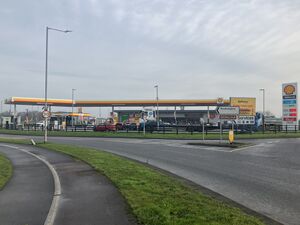
Pocklington services
A1079 at Pocklington Roundabout
(Limited road signage.)
YO42 1AD
map and directions
Single site located at a junction.
Plans to expand Broadhelm Business Park saw a service area developed on the A1079.
Facilities
Catering: KFC Drive Thru, Starbucks Drive Thru Outdoor Space: Grass verge by KFC; public footpath connections Forecourt: Shell, Nisa Local, Subway, Costa Express, Fanta Frozen, f'real Milkshakes, Rollover, Tango Ice Blast, Car Wash, Jet Wash, Free Cash Machine
Parking Prices
Short-stay customer car parking is available at all facilities. No HGV parking is available.
This information is provided to us by third parties. You should always check with staff on site.
Contact Details
🏢 Address:
Pocklington Services
Broadhelm Close
Pocklington
York
East Riding of Yorkshire
YO42 1AD
Trivia and History

Broadhelm Business Park was first proposed in 2006, and this corner (known as Hodsow Field) was designated a leisure area, which could include a hotel and a pub-restaurant. The project had to wait until the new roundabout had been constructed on the A1079 in 2011, by which point the economy had gone downhill and hotel operators had lost interest.
Having something to pull passers-by in was key to the business park, so a new plan was created with a petrol station, drive thru and a pub-restaurant. The petrol station opened in 2014, by The Brookfield Group, and instead two drive thru units opened in the following years.
A Burger King Drive Thru and Enterprise Car Hire were added on the opposite side of Hodsow Lane in 2022, meaning the range of facilities now fills all the space available.
Signage Issues
The service area hasn't been given full signing by the local authority, but "Services" is used as a generic destination on the roundabout, to highlight the entrance. It is also shown as "Services" by Ordnance Survey.
By coincidence, there was once a Little Chef here. It opened in the 1970s and closed in around 1987.
Alternatives
| Previous: | Next: | |
| Coastways (5 miles) | Services on the A1079 | Bilbrough Top (A64 west, 18 miles) Poppleton (A1237 north, 20 miles) |

