Main Page | Photo Gallery | Map
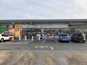
This is a map of official service areas with a Nisa Local store. Tapping each icon will reveal more details, with a link to a detailed database page.
If the map doesn't load properly, try refreshing this page. There are more search options below.
Loading map... If nothing is happening, try refreshing the page.
{"minzoom":5,"maxzoom":15,"mappingservice":"leaflet","width":"auto","height":"575px","centre":{"text":"","title":"","link":"","lat":53.917281000000002677552402019500732421875,"lon":-2.285156000000000187100113180349580943584442138671875,"icon":""},"title":"","label":"","icon":"","lines":[],"polygons":[],"circles":[],"rectangles":[],"copycoords":false,"static":false,"zoom":6,"defzoom":14,"layers":["OpenStreetMap.DE"],"image layers":[],"overlays":[],"resizable":true,"fullscreen":false,"scrollwheelzoom":true,"cluster":false,"clustermaxzoom":20,"clusterzoomonclick":true,"clustermaxradius":80,"clusterspiderfy":true,"geojson":"","clicktarget":"","imageLayers":[],"locations":[{"text":"\u003Cdiv class=\"mw-parser-output\"\u003E\u003Cp\u003E\u003Ca href=\"/Ram_Jam\" title=\"Ram Jam\"\u003ERam Jam services\u003C/a\u003E\u003Cbr /\u003E\u003Cspan\u003E\u003Ci\u003E(available northbound only)\u003C/i\u003E\u003C/span\u003E\u003Cbr /\u003E\u003Cbr /\u003EOperated by MPK Garages\u003Cbr /\u003EHGV access: fuel only\u003Cbr /\u003E\u003Cbr /\u003EA1 northbound between Stamford and Colsterworth\n\u003C/p\u003E\u003C/div\u003E","title":"Ram Jam services(available northbound only)Operated by MPK GaragesHGV access: fuel onlyA1 northbound between Stamford and Colsterworth\n","link":"","lat":52.7324339999999978090272634290158748626708984375,"lon":-0.600284409999999990503738445113413035869598388671875,"icon":"/wiki/images/b/b9/Icon-TRSA.png"},{"text":"\u003Cdiv class=\"mw-parser-output\"\u003E\u003Cp\u003E\u003Ca href=\"/Luxmore\" title=\"Luxmore\"\u003ELuxmore services\u003C/a\u003E\u003Cbr /\u003EOperated by Ascona Group\u003Cbr /\u003E\u003Cbr /\u003EA180 between Scunthorpe and Grimsby\n\u003C/p\u003E\u003C/div\u003E","title":"Luxmore servicesOperated by Ascona GroupA180 between Scunthorpe and Grimsby\n","link":"","lat":53.60939799999999877400114201009273529052734375,"lon":-0.2427861799999999903310055060501326806843280792236328125,"icon":"/wiki/images/b/b9/Icon-TRSA.png"},{"text":"\u003Cdiv class=\"mw-parser-output\"\u003E\u003Cp\u003E\u003Ca href=\"/Tickled_Trout\" title=\"Tickled Trout\"\u003ETickled Trout services\u003C/a\u003E\u003Cbr /\u003EOperated by Brookfield Group\u003Cbr /\u003EHGV access: fuel only\u003Cbr /\u003E\u003Cbr /\u003EM6 at J31\u003Cbr /\u003E\u003Cb\u003ESignposted from the road?\u003C/b\u003E From A59 only\n\u003C/p\u003E\u003C/div\u003E","title":"Tickled Trout servicesOperated by Brookfield GroupHGV access: fuel onlyM6 at J31Signposted from the road? From A59 only\n","link":"","lat":53.76516099999999909186954027973115444183349609375,"lon":-2.640213699999999885648094277712516486644744873046875,"icon":"/wiki/images/b/b9/Icon-TRSA.png"},{"text":"\u003Cdiv class=\"mw-parser-output\"\u003E\u003Cp\u003E\u003Ca href=\"/Crossgates\" title=\"Crossgates\"\u003ECrossgates services\u003C/a\u003E\u003Cbr /\u003EOperated by Ascona Group\u003Cbr /\u003E\u003Cbr /\u003EA44 between Leominster and Rhayader\n\u003C/p\u003E\u003C/div\u003E","title":"Crossgates servicesOperated by Ascona GroupA44 between Leominster and Rhayader\n","link":"","lat":52.27523599999999959209162625484168529510498046875,"lon":-3.33415209999999984091800797614268958568572998046875,"icon":"/wiki/images/b/b9/Icon-TRSA.png"},{"text":"\u003Cdiv class=\"mw-parser-output\"\u003E\u003Cp\u003E\u003Ca href=\"/Rowborough\" title=\"Rowborough\"\u003ERowborough services\u003C/a\u003E\u003Cbr /\u003EOperated by AKV Garages\u003Cbr /\u003Eno HGVs\u003Cbr /\u003E\u003Cbr /\u003EA429 between Leamington Spa and Moreton-in-Marsh\n\u003C/p\u003E\u003C/div\u003E","title":"Rowborough servicesOperated by AKV Garagesno HGVsA429 between Leamington Spa and Moreton-in-Marsh\n","link":"","lat":52.05000100000000173849912243895232677459716796875,"lon":-1.6647787000000000556809709451044909656047821044921875,"icon":"/wiki/images/b/b9/Icon-TRSA.png"},{"text":"\u003Cdiv class=\"mw-parser-output\"\u003E\u003Cp\u003E\u003Ca href=\"/Chippenham_Pit_Stop\" title=\"Chippenham Pit Stop\"\u003EChippenham Pit Stop \u003C/a\u003E\u003Cbr /\u003E\u003Cbr /\u003EA350 at M4 J17\u003Cbr /\u003ELimited road signage.\n\u003C/p\u003E\u003C/div\u003E","title":"Chippenham Pit Stop A350 at M4 J17Limited road signage.\n","link":"","lat":51.51344499999999726469468441791832447052001953125,"lon":-2.10921409999999998063913153600879013538360595703125,"icon":"/wiki/images/b/b9/Icon-TRSA.png"}],"imageoverlays":null}
Where an operator is given, this refers to the whole complex. Who operates each unit can get complicated, and you can normally see this by tapping the site name and scrolling to the 'contact details' section.
The colour of the icon gives you a rough idea how big the services are. Blue means motorway, green means major A-road, white means local services, black means designed for lorries.
Download full list in KML (for Google Earth and sat navs)
Narrow Your Search Down
Use any of these boxes to add more search criteria, and to show which service station with a Nisa is nearest to you.
It's best to start by using just one of the drop-down boxes - you can use another if you get too many results.
Main Page | Photo Gallery | Map