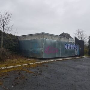
Kentford services
(former)


| Road: | A14 between J38 and J39 |
| Address: | Kentford Services Kentford Newmarket Suffolk CB8 7PZ |
| Opened: | 1979 |
| Closed: | 2004 |
| Services type: | Two sites located between junctions, with no public connection between them |
A former dual-sided service station located on the A14 near Newmarket, Kentford services has been derelict for quite a long time.
Former Facilities
Catering: Little Chef Forecourt: BP, Shop
Trivia and History
The A45 (now A14) Kentford Bypass opened in 1975, and within the next few years a dual-sided service area with a pair of Little Chef restaurants and BP filling stations had opened. Both Little Chefs opened in July 1979, with one of them being struck by lightning on 28 July 1995.
The forecourts closed in July 1997 and were soon demolished, but the sales shops were left to stand. The Little Chefs continued to trade on and there were plans to turn the westbound side into a Burger King drive-thru, which didn't happen.
Both Little Chef restaurants closed around 2004, during the Permira closure wave which targetted the smaller branches they felt had less potential.
Urban explorers revealed the state of the abandoned northbound service area in September 2005, including the shop building and the Little Chef, which had fallen into disrepair with broken windows, a messy interior and a collapsing ceiling. Later that year, a broken water pipe caused the northbound restaurant's kitchen to flood.
A further series of photos shared in January 2006 show the shop and Little Chef buildings in an even worse state of disrepair, with all remaining furniture having been removed. The northbound restaurant was boarded up shortly after.
Afterwards, the shop buildings (which were once full of broken junk after the services had closed) were demolished, but the Little Chefs were left untouched.
As of 2025, nothing has ever come of Kentford, despite both buildings being up for sale through Ashwell Rogers. The car parks remain visible but are extremely overgrown, and the slip roads are fenced off.
Weirdly enough, the site is still listed as a service area in Ordnance Survey maps as late as 2020.
Kentford Bury Road
Immediately to the south of Kentford services is the old road, Bury Road. This had the original Kentford branch of Little Chef which opened in the late 1960s and closed a few years later, when the bypass opened.
Area Map
This is an automatically generated map of the surrounding area. You can use the button on the right to switch between a map and an aerial photo. Historic maps may be available at SABRE Maps.
🗺 Grid reference: TL719670 | See GeoHack for modern layers