Lockerbie truckstop
(former)
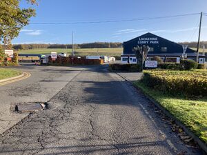
Lockerbie Lorry Park
Only one photo tagged with Lockerbie. If you have one, why not
upload it?
Road: | A74(M) at J16 (also accessible to traffic on the B7076) |
Address: | Lockerbie Truck Stop
B7076
Hangingshaw
Lockerbie
Dumfries and Galloway DG11 2SL |
Signposted from the road? | Yes |
Closed: | 2022 |
Services type: | Single site located at the side of the road |
For a brief period, there was a lorry park positioned on the same exit as Annandale Water services. It was positioned on the B7076 (the old A74), providing access to A74(M) J16 and J17, and signposted from the road.
The facility closed on 28 October 2022 as the land was sold to a new owner who did not wish to continue the facility.
Facilities
Catering: Restaurant, O'Neill's Bar
Shops: Shop, Hotel
Amenities: Free Cash Machine, Launderette, Showers, Truckwash
Forecourt: Fuel
Area Map
This is an automatically generated map of the surrounding area. You can use the button on the right to switch between a map and an aerial photo. Historic maps may be available at SABRE Maps.
Loading map... If nothing is happening, try refreshing the page.
{"minzoom":12,"maxzoom":17,"mappingservice":"leaflet","width":"auto","height":"460px","centre":{"text":"","title":"","link":"","lat":55.19238899999999858891897019930183887481689453125,"lon":-3.406848000000000098452801466919481754302978515625,"icon":""},"title":"","label":"","icon":"","lines":[],"polygons":[],"circles":[],"rectangles":[],"copycoords":false,"static":false,"zoom":15,"defzoom":14,"layers":["OpenStreetMap.France","Esri.Aerial"],"image layers":[],"overlays":[],"resizable":true,"fullscreen":false,"scrollwheelzoom":false,"cluster":false,"clustermaxzoom":20,"clusterzoomonclick":true,"clustermaxradius":80,"clusterspiderfy":true,"geojson":"","clicktarget":"","imageLayers":[],"locations":[{"text":"\u003Cdiv class=\"mw-parser-output\"\u003E\u003Cp\u003ELockerbie site\n\u003C/p\u003E\u003C/div\u003E","title":"Lockerbie site\n","link":"","lat":55.19238899999999858891897019930183887481689453125,"lon":-3.406848000000000098452801466919481754302978515625,"icon":"/wiki/images/a/a6/Icon-closed.png"}],"imageoverlays":null}
🗺 Grid reference: NY105895 | See GeoHack for modern layers